Geospatial — Location-Driven Data
What Is Geospatial?
Geospatial is simply “geo,” meaning of or relating to the earth, and “spatial,” meaning of or relating to space. Geospatial intelligence gives organizations the ability to analyze imagery and geographic details to describe, assess and visually depict physical features and human activity around the world. This has many practical implications, particularly for surveillance, national security and crisis response — and on a lighter note, marketing opportunities, event planning, brand monitoring and social networking.
Organizations often use geospatial technology to quickly learn more about influencers, customers, prospects or any group of people that interests them in a particular area — in real time or over a period of time. Geospatial analysis of this gathered information provides context about time and location. Geospatial insights adds another layer of detail to other data they may have already collected, detail that often provides much more precise and actionable insights that can save precious time, money and resources.
Geospatial Data Has Its Benefits:
- Find data faster: Manual research takes time and resources, but geospatial insights are automated and fast so you can find what you’re looking for quickly.
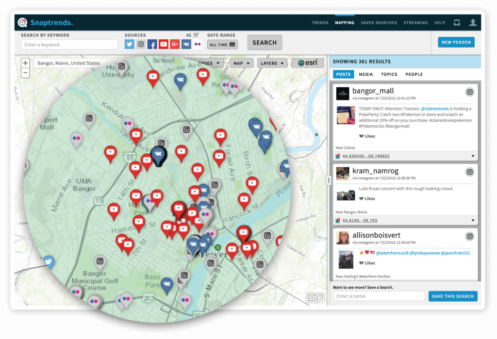
- Visualize results: The beauty of geospatial insight is that it is completely location-based. Results can be plotted on a social media map so you can have a graphic representation of where conversations are happening.
- Improve precision: Geospatial data offers precise locations so you don’t have to guess or extend your strategy beyond what’s necessary.
- Make better decisions: When you know more, you can make more informed decisions. Geospatial insight adds an extra layer of detail that is often critical to making the best decisions and driving effective strategies.

Visualizing WHERE social media conversations happen adds the context of location to social media data
Snaptrends Geospatial Insights
Snaptrends is built 100 percent to leverage geospatial technology. Our software is built from the ground up to access multiple social media networks simultaneously to find the exact information you need to make critical decisions. We place a geofencing lens over a user-defined area of any shape or size, from an actual physical address like a stadium or school to an entire continent. Our geospatial technology “listens” to social media chatter to find the conversations that matter to your organization; then we pinpoint where those conversations are happening. Our results are so accurate, you can plot them on a map for the most granular detail necessary for your requirements.
Using Snaptrends, you have the ability to:
- Locate influencers and audiences anywhere around the world: Snaptrends’ automated analytical and visualization tools enable you to digest large amounts of data and “see” data and influencer correlations. You can view your results from a number of different perspectives, including multiple community or relationship diagrams, sentiment and mood graphs, and topic of conversation bubbles.
- Hear the full spectrum of the social conversations: With Snaptrends’ proprietary algorithms and processes, you can “listen” to conversations across multiple social media channels individually or simultaneously from any area upon which you place a lens. No conversation is missed and different conversations from the same person can be integrated, despite the number of social networks on which these conversations are happening.
- Choose mapping overlays: Our software is flexible and customizable, enabling you to choose from a variety of mapping overlays, from heat maps and activity clusters to weather radar. The map viewing options also allow you to locate posts on a standard map, satellite or street view so you get the detail you need.
- Filter results: Snaptrends filters your results, eliminating irrelevant social media data automatically so you can focus on the conversations and posts that matter to you and your organization. Refine your results using the flexibility of filtering by location, keywords, users, date ranges, media types and Boolean search operators.
- View posts in real time: Snaptrends gives you the ability to see posts and conversations as they happen using the Live View option. We make it easy for you to zoom in on an area of the map to view conversations in real time so you can make decisions and respond quickly.
No other social media monitoring solution offers the level of detail, flexibility and ease of use as Snaptrends’ geospatial technology. We help organizations of any industry leverage geospatial data to guide strategies, protect people, places and assets, and engage with people on a personal level.
